A Tectonics Article By Catherine Ross
The Seychelles "Plate" is not a plate at all; it is a plateau. The Seychelles Islands are the highest portions of an undersea plateau, the Mascarene Plateau, which measures approximately 60,000 square miles and rises one to two miles above the surrounding seafloor (see Fig. 1). This high area is northwest of the Madagascar Plate and formed from India leaving behind continental fragments as it broke off from Gondwana. Both the Madagascar microplate and Seychelles microplate lie within the Somali Plate. Fig. 2 displays the relative ages of crust as well as the various plateaus and banks that are connected to the Seychelles Plateau through first through the Marion plume, then the Deccan-Reunion plume.
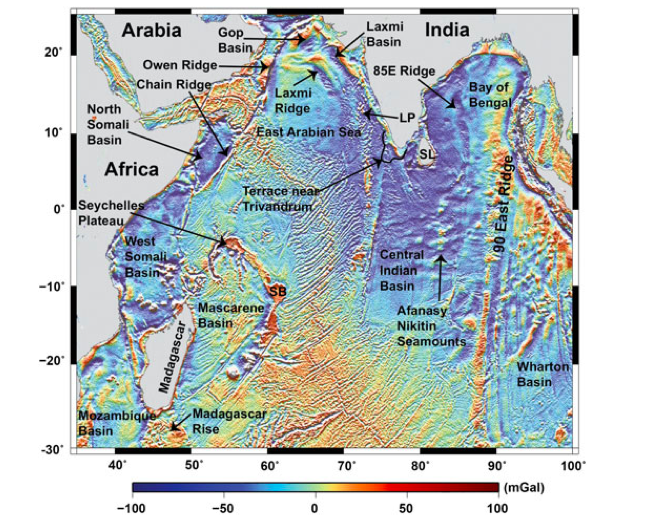
Figure 1. Free Air Gravity Anomalies in the Indian Ocean (Sandwell & Smith, 2009) with important features labelled.
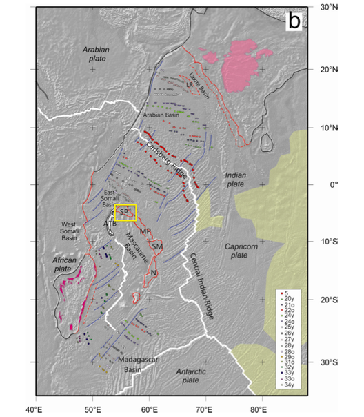
Figure 2. Tectonic Setting surrounding the Seychelles. Yellow box: Seychelles Plateau. Dark blue lines: fracture zones; light blue lines: spreading centres; pink lines: features of the extended margins of Indian and African plates; dashed pink lines: seaward edges of gravity lows flanking the continental slopes. Pink area: Deccan Traps. ATB, Amirante trench and banks; MP, Mascarene Plateau; N, Nazareth Bank; SM, Salha da Maya Bank; SP, Seychelles Plateau (Eagles, G. and H. H. Hoang, 2013)
GEology
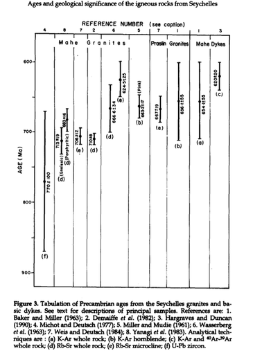 Figure 5. Ages of Seychelles granites and dykes (Plummer, 1995).
The island of Mahè is composed of grey and porphyritic granites while the Praslin island is composed of pink granites. The granites found in the Seychelles are the same granites found on Madagascar and northwest India. Both were found to have been formed around ~750 Ma (Tucker, 2001). However, the Mahè granites are dated as slightly older than the Praslin granites (see Fig. 5 for slight differences in age between the two granites) The granites are cut by doleritic dykes which intruded in the Precambrian and then again in the early Tertiary (Suwa et al., 1983). The islands of Silhouette and Île du Nord were formed by 61-67 Ma alkaline igneous complexes (Dickin et al., 1986). These islands have ages similar to the doleritic dykes and have a probable link to the Deccan Traps of India as the Seychelles were positioned next to India (Collier et al., 2008) at that time. Drilling by Amoco in the southwestern most part of the Seychelles plateau found Triassic/ Jurassic hydrocarbons which signify the probability of continental crust in that region (Coakley, 1997).
Tectonic History
The following is a tectonic map of the Seychelles region. The continental crust petrology is classified by color. However, because Africa and Madagascar are compromised of many different petrological regions, the black outlines of the regions makes it hard to differentiate between the different petrological regions. The rifting zones are shown in red and the oldest oceanic crust is green, then orange, yellow, and pink is the youngest. The Seychelles Plateau is the light blue region northeast of Madagascar.
| seychelles_tectonic_map-1.pdf |
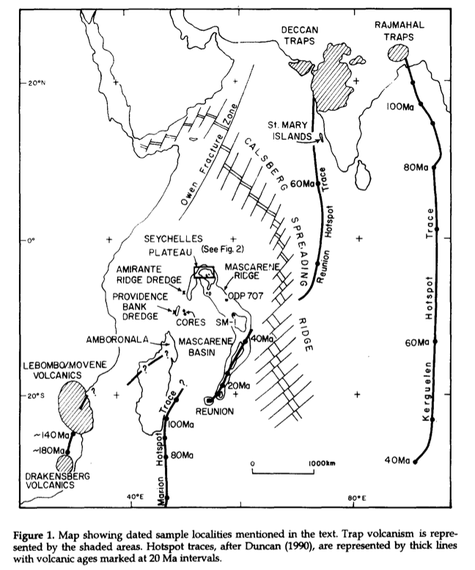
Figure 4. Tracks of the Marion and Reunion Hotspots & Deccan Traps (Plummer, 1995).
Plummer (1995) summarizes the tectonic history of the Seychelles as the following:
- In the late Precambrian, the Seychelles were formed by the emplacement of Mahè granites between 710-680 Ma, the emplacement of Praslin granites at ~665 Ma, and the dyke at ~620 Ma, while the Seychelles was a part India, which in turn was a part of Eastern Gondwana.
- Little additional magmatic activity is noted in the region until the Early Jurassic, ~190 Ma, which was characterized by the Karoo flood-basalt eruption. After the basalt eruption, the Marion hotspot arose, evidenced in the interbedded devitrified ash.
- The Early Cretaceous, ~135 Ma, was marked by volcanism along the Davie Fracture Zone and some volcanics related to the migrating Marion hotspot (seen in the mid-lower region of Fig. 3). This is evidenced by doleritic dykes of the Seychelles.
- Additional volcanism due to the Marion hotspot (see Fig. 3) in the Early Cretaceous, ~120 Ma, is the probable cause of formation of the Saya de Mahla Bank.
- The Late Cretaceous was also marked by volcanism ~96-84 Ma which is around the same time as rifting between Seychelles and Madagascar began shown by the acid volcanics in northeast Madagascar and the west coast of the Indian plate (Plummer, 1995). This is when the first oceanic crust was formed in the Mascarene Basin (Plummer and Belle, 1995).
- Between 82-65 Ma, a compressive sinistral transform fault between the Indian (Seychelles included) and Somali plates created the an arc-like portion of Amirante ridge (Plummer, 1995). However, the nature of the crust below Amirante ridge is still puzzling geologists today (Hammond, 2013)
- During the Late Cretaceous and Early Tertiary, the Deccan flood-basalt volcanism (seen in Fig. 3 in India) was thought to have potentially caused rifting between the Seychelles and India and created the Carlsberg Spreading Ridge (Plummer, 1995). In summary, the Madagascar plate rifted from India/Seychelles and ceased moving as India/Seychelles moved northeast. Soon after, the Seychelles and Indian plates then separated. Finally, the Indian plate moved northeastward and the Seychelles remained stagnant (essentially now a part of the Madagascar plate). The Seychelles is currently slowly subsiding at rate of only a fraction of an inch every millennium into the Indian Ocean (Howell, 2000).
 Figure 4. Plume & traps in relation to the
creation of the Indian Ocean (Hammond, 2013).
Figure 4. Plume & traps in relation to the
creation of the Indian Ocean (Hammond, 2013).
Underneath the Seychelles lies a layer of lower crustal intrusions suggesting that the Seychelles lay at the edge of the Deccan plume when the Deccan Traps were emplaced (Hammond et al., 2013). The Deccan Traps, were formed by an outpouring of basaltic lava from Reunion Plume (seen in Fig. 3 & Fig. 4 ) over an area of ~2 mile thick basalt and covering 400,000 square miles. The Deccan flood basalts covered a majority of the Seychelles Plateau right as it was starting to rift from India but some of the Precambrian granites are still seen (Howell, 2000). The presence of the Marion plume is also worth noting because of its potential influence on the Seychelles rifting from Madagascar. These plumes may have also caused the initial rifting of Madagascar, India, and the Seychelles; the plumes are the reason that the lithosphere under the Seychelles is so unusual (Hammond et al., 2012). Coakley (1997) concludes the Seychelles microplate consists of both continental and oceanic crust. Based on data from Hammond et. al. (2013), the northern Amirantes is also continental crust. The slivers of continental crust in the Seychelles microplate correlate with slivers of continent crust in the Indian Ocean, and in other regions of continental breakup (Hammond et al., 2013). Müeller (2008) created following animation that summarizes the tectonic evolution of the Seychelles Region from 200 Ma (Jurassic) to 0 Ma (Holocene).
References
Coakley, G.J., 1997. The mineral industry of islands of Comoros, Mauritius, Reunion and Seychelles. Technical report. USGS, Reston, Virginia.
Collier, J.S., Sansom, V., Ishizuk, O., Taylor, R., Minshull, T.A., Whitmarsh, R.B., 2008. Age of Seychelles–India break-up. Earth and Planetary Science Letters, 272, 264–277.
Dickin, A.P., Fallick, A.E., Halliday, A.N., MacIntyre, R.M., Stephens, W.E., 1986. An isotopic and geochronological investigation of the younger igneous rocks of the Seychelles microcontinent. Earth and Planetary Science Letters, 81, 46–56.
Eagles, G. and H. H. Hoang. 2013. "Cretaceous to Present Kinematics of the Indian, African and Seychelles Plates." Geophysical Journal International 196 (1): 1-14.
Hammond, J.O.S., Collier, J.S., Kendall, J., Helffrich, G., Rumpker, G., 2012. Plume scar in the mantle lithosphere beneath the Seychelles revealed by seismic imaging. Earth and Planetary Science Letters, 355–356, 20–31.
Hammond, J.O.S., Kendall, J.-., Collier, J.S. & Rümpker, G. 2013, "The extent of continental crust beneath the Seychelles", Earth and Planetary Science Letters, 381, 166-176.
Howell, Paul, 2000. Seychelles Through Time. NOVA, n.d. Web. 26 Jan. 2014. <http://www.pbs.org/wgbh/nova/eden/time.html>.
Plummer, P.S. 1995, "Ages and geological significance of the igneous rocks from Seychelles", Journal of African Earth Sciences, vol. 20, no. 2, pp. 91-101.
Plummer, P.S. & Belle, E.R. 1995, "Mesozoic tectono-stratigraphic evolution of the Seychelles microcontinent", Sedimentary Geology, vol. 96, no. 1-2, pp. 73-91.
Müller, R.D., Sdrolias, M., Gaina, C. and Roest, W.R., 2008. Age, spreading rates and spreading asymmetry of the world's ocean crust. Geochem. Geophys. Geosyst., 9(Q04006): doi:10.1029/2007GC001743.
Sandwell, D. T., and W. H. F. Smith (2009), Global marine gravity from retracked Geosat and ERS-1 altimetry: Ridge segmentation versus spreading rate, J. Geophys. Res.-Solid Earth, 114, doi:10.1029/2008JB006008.
Suwa, K., Yanagi, T., Tokeida, K., Umemura, H., Asami, M. and Hoshino, M., 1983. Geology and petrology of the Seychelles Islands. In: Preliminary Report African Studies Nagoya University 8 (Edited by Suwa, K.) pp3-21. Nagoya, Japan.
Tucker, R.D., Ashwal, L.D. & Torsvik, T.H. 2001, "U–Pb geochronology of Seychelles granitoids: a Neoproterozoic continental arc fragment", Earth and Planetary Science Letters, 187, 27-38.
